
This chapter covers Some Major Ecosystems, the final chapter from the 2nd Year (FSc Part-II) Biology syllabus of the Punjab Curriculum and Textbook Board (PTB/PCTB). Life on earth, especially on land, is affected by both weather and climate: weather refers to short-term fluctuations in temperature, humidity, cloud cover, wind and precipitation over hours or days, while climate refers to overall patterns of weather that prevail from year to year or even century to century in a particular region. Building on the general concept of the ecosystem from the previous chapter, this chapter discusses aquatic and terrestrial ecosystems in detail. These notes are prepared by freebooks.pk.
The chapter covers the aquatic (hydrospheric) ecosystem and its productivity, the three life zones of fresh water lakes (littoral, limnetic and profundal) and human-caused eutrophication, the terrestrial (lithospheric) ecosystem and its adaptations, and Pakistan's major terrestrial ecosystems: temperate deciduous forests, coniferous alpine and boreal forests (taiga), grassland ecosystems, desert ecosystems, and the tundra ecosystem, concluding with a discussion of human impact on ecosystems.
Learning Objectives
- Distinguish between weather and climate.
- Describe the hydrospheric (aquatic) ecosystem and the factors determining its productivity.
- Identify the three life zones of a fresh water lake (littoral, limnetic, profundal) and describe eutrophication.
- Describe the terrestrial (lithospheric) ecosystem, the factors influencing life on land, and adaptations for land life.
- List the major divisions of the terrestrial ecosystem and identify Pakistan's major ecosystems and their locations.
- Describe the climate, plant life, animal life and human impact of temperate deciduous forests and coniferous (taiga) forests.
- Describe the climate, plant life, animal life and human impact of grassland and desert ecosystems.
- Describe the tundra ecosystem and summarize the overall impact of humans on natural ecosystems.
Key Concepts
Climate and the Aquatic (Hydrospheric) Ecosystem
Weather refers to short-term fluctuations in temperature, humidity, cloud cover, wind and precipitation over periods of hours or days, while climate refers to overall patterns of weather that prevail from year to year, even century to century, in a particular region. The hydrospheric ecosystem is a system in water where living and non-living components exchange materials and energy transfer also takes place within water. Salt-water oceans and seas are the largest ecosystems on earth, forming about 71% of its surface, while fresh water ecosystems cover less than 1%. The unique properties of water give aquatic ecosystems some common features: water changes temperature more slowly than air, so aquatic temperatures are more moderate for supporting life; although water appears transparent, it absorbs considerable light energy, and light intensity decreases rapidly with depth, so at depths of 600 feet or more little light remains to power photosynthesis; nutrients tend to concentrate near bottom sediments where light levels are often too low for photosynthesis; and water, abundantly available with appropriate temperature, is essential for all metabolic processes, with energy and nutrients being the major factors determining the quantity and type of life present.
The productivity of an aquatic ecosystem can be indicated by consumption of carbon dioxide and evolution of oxygen during photosynthesis, and is basically determined by light and nutrients; light intensity and quality vary with water depth, so primary productivity also varies with light, while nutrient amounts change with season, and productivity varies from zone to zone. Aquatic environments can be broadly classified into fresh water and marine (salty) water.
Fresh Water Lakes: Life Zones and Human Impact
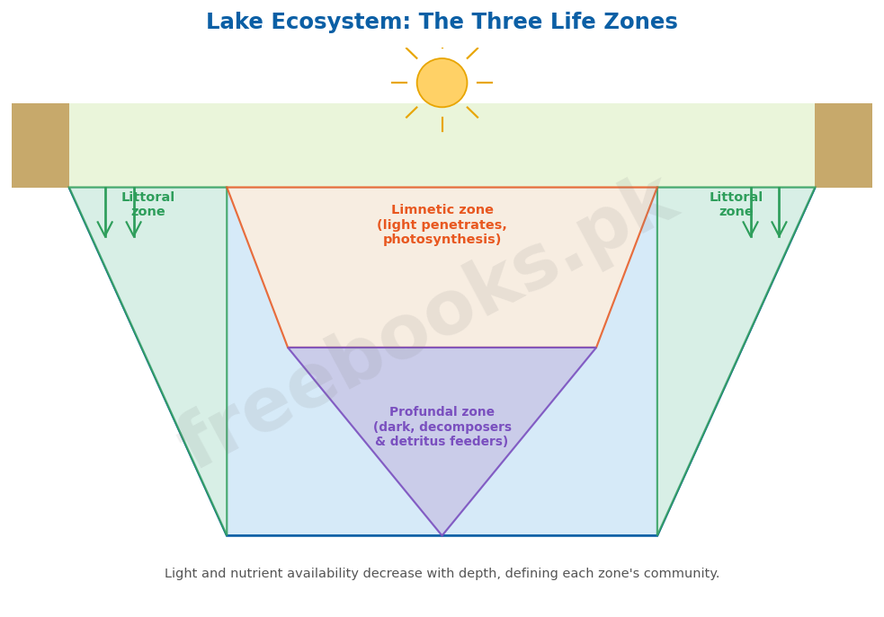
Fresh water lakes vary tremendously in size, depth and nutrient content, including distinct life zones and temperature stratification; the distribution of life in lakes depends on access to light, nutrients, and a place for attachment, dividing the lake ecosystem into three main zones. The littoral zone (near-shore) has shallow water where plants find abundant light, anchorage and nutrients from bottom sediments; plant communities here are the most diverse, including water lilies and submerged vascular plants and algae, and this zone also has the greatest diversity of animals, including plankton (microscopic organisms divided into phytoplankton – photosynthetic protista, bacteria and algae – and zooplankton – protozoa and tiny crustaceans), along with littoral invertebrates (small crustaceans, insect larvae, snails, flatworms, Hydra) and vertebrates (frogs, aquatic snakes, turtles). As water depth increases away from shore, plants can no longer anchor while still collecting enough light, dividing the open water area into the upper limnetic zone, where enough light penetrates for photosynthesis (with cyanobacteria as phytoplankton producers, eaten by protozoa and small crustaceans, which are in turn consumed by fish), and the lower profundal zone, where light is insufficient for photosynthesis and organisms are nourished mainly by detritus falling from the littoral and limnetic zones and incoming sediment, inhabited by decomposers and detritus feeders such as snails, certain insect larvae, bacteria, fungi and fish.
Human activities may greatly accelerate eutrophication, since nutrients are carried into lakes from farm feedlots and sewage; even after solid wastes are removed, water discharged from sewage treatment plants is often rich in phosphates and nitrates, and rainwater washes fertilizer and cattle manure runoff into lakes, enriching the water and supporting excessive growth of phytoplankton. Producers like blue-green algae form a surface scum, depriving submerged plants of sunlight, causing them to die; the dead plant bodies are decomposed by bacteria that use up dissolved oxygen, causing fish, snails and insect larvae to die from oxygen deprivation, and their decaying bodies fuel further bacterial growth, further depleting oxygen; even without oxygen, certain foul-smelling-gas-producing bacteria thrive, so a polluted lake, while full of life and nutrients, smells bad, with most trophic levels including fish eliminated and bacteria and blue-green algae dominating the community. Another serious cause of polluted water is acid produced by the burning of fossil fuels, posing a different threat, as few organisms can withstand the low pH of acidified lakes.
The Terrestrial (Lithospheric) Ecosystem: Factors and Adaptations
The ecosystem present on land or soil is called the terrestrial or lithospheric ecosystem, which receives plenty of light and abundant soil nutrients, but water is limited and very unevenly distributed in both place and time. Temperature, like water, is very unevenly distributed on land in place and time: at the poles, average temperature is below freezing; in temperate zones, favourable temperatures occur only during certain seasons; but tropical zones have uniformly warm, moist climates. In the terrestrial ecosystem, air is in constant motion, so its composition (including oxygen and carbon dioxide levels) is more uniform and beneficial throughout.
Plants and animals shifting from water to land developed various adaptations for terrestrial life, including supporting tissues – vascular bundles (xylem-phloem) in plants and a skeleton in animals – to support them against gravity, and mechanisms for conservation of water, such as homeostasis, and temperature regulation, such as bark in plants and skin in animals. The terrestrial ecosystem can be divided into several main types: the forest ecosystem (further sub-divided into tropical rain forests, temperate deciduous forests, and coniferous alpine and boreal forests), the grassland ecosystem, the desert ecosystem, and the tundra ecosystem.
Pakistan's Ecosystems and the Temperate Deciduous Forests
Pakistan has a wide variety of seasons and climates, ranging from hot and dry in the plains to cold and snowy in the mountains, and hosts a range of major terrestrial ecosystems: temperate deciduous forests (Shogran and Neelam valley), coniferous alpine and boreal forests (northern mountains of Kaghan, Malam Jabba/Swat, Dir and Chilas), grassland ecosystem (Gilgit, Kashmir, Waziristan, lower Chitral and North Kalat), desert ecosystem (Mianwali, Bhakkar; Fort Abbas, Bahawalnagar, Yazman, Bahawalpur, Khanpur and Rahim Yar Khan; and Sindh), and tundra ecosystem (the Karakoram and Hindu Kush mountains).
In Pakistan, temperate deciduous forests occur in the Neelam valley and Shogran; worldwide, these forests originally covered India, Southeast Asia, eastern North America, Europe, China, Australia, Japan, and North and South America. Farther from the equator, rainfall is not constant, with pronounced wet and dry (summer and winter) seasons; during dry seasons trees cannot get enough water from the soil to compensate for evaporation from their leaves, so they have adapted by shedding leaves to minimize water loss, delaying new leaf formation if rains fail to return on schedule. Average rainfall is 750-1500 mm, with moderate temperatures ranging from 4 to 30 degrees Celsius; dominant plants include Taxus baccata, Pinus wallichiana, and Berberis lyceum, with herbs and shrubs up to 5 metres, grasses, ferns and other herbaceous plants forming the field layer, and mosses, liverworts and lichens at the litter-covered floor. Common animals include the rhesus monkey (Macaca mulatta), black bear (Selenarctos thibetanus), leopard cat (Felis bengalensis), deer, and wolves, alongside microorganisms such as bacteria, fungi and earthworms that convert litter into organic matter. The soil is grayish-brown, very fertile and rich in organic matter with maximum water-holding capacity; human impact through lumber harvesting for agriculture has reduced many deciduous forests worldwide, and large predators such as black bear, deer, wolves, bobcats and mountain lions have been largely wiped out by humans.
Coniferous Alpine and Boreal Forests (Taiga)
In Pakistan, coniferous forests occur in upper Kaghan, Dir and Chilas, and Malam Jabba in the Swat valley; worldwide, they stretch across Eurasia and North America, just south of the tundra, and are also called taiga. Conditions in the taiga are harsher than in temperate deciduous forest, with longer, colder winters and a shorter growing season too brief for trees to regrow foliage each year; as a result, evergreen coniferous trees with small waxy needles dominate this forest type, their waxy coating and small surface area reducing water loss by evaporation during cold months, allowing needles to remain on trees year-round. Coniferous forests at high altitude are called alpine, while those at high latitude are called boreal.
The taiga has a constant cover of snow characterized by long, severe winters, with temperatures ranging from below freezing up to 10 degrees Celsius; because of the harsh climate, biodiversity is much lower than in deciduous forest. Large mammals present include bison, wolf, black bear, deer, and Marco Polo sheep, alongside smaller animals such as the Kashmir flying squirrel, snowshoe hare, wolverine, and crossbills; plant life includes Pinus wallichiana, Pinus roxburghii, Abies pindrow, Picea smithiana, and Cedrus deodara. Due to the severity of the climate and remoteness of these regions, most coniferous forests remain relatively undisturbed, though they are a major source of lumber for construction, leading to clearing of these forests in various parts of the world.
The Grassland Ecosystem
Grassland ecosystems in Pakistan are found in Gilgit, Kashmir, Waziristan, lower Chitral and North Kalat; worldwide, a large grassland region occurs in the center of the Eurasian continent. Grasslands in temperate climates, lacking woody plants, are called prairies (such as the Prairies of North America and the Pampas of Argentina), while grasslands in tropical climates with woody trees are called savannas. Grasslands typically face severe droughts, with annual rainfall of about 250-750 mm (reaching about 1500 mm in tropical and subtropical grasslands), occurring in regions where mean annual rainfall is midway between forest and desert conditions, generally featuring a continuous grass cover with virtually no trees except along rivers; water and fire are the crucial factors in the competition between grasses and trees.
The dominant plant species are graminoids (grasses and grass-like plants), along with certain forbs such as composites and legumes. Grasslands show characteristic layering: tall grasses (Andropogon, Panicum) form the first layer, mid-high grasses (Stipa, Sporobolus, Oryzopsis) form the second layer, and short grasses, forbs, mosses and lichens form the third layer. Soil moisture is limited due to low precipitation and high evaporation; the upper soil layer where grasses are rooted is normally moist, but deeper layers remain constantly dry, and the soil tends to be impermeable with excessive salinity. Dominant animal species are herbivores, with numerous invertebrates including insects (grasshoppers can become numerous enough to compete with other herbivores for plant foliage); predators include reptiles, amphibians and mammals such as lizards, toads, turtles, foxes and wolves; decomposers include bacteria, actinomycetes and fungi (molds, yeasts, mushrooms, bracket fungi); and large animals like zebras, wild horses and bison are also significant. Primary production in temperate grassland is about 700-1500 g/m² annually, exceeding 4000 g/m² in sub-humid tropical grassland; human impact includes crop production and livestock management, with only a small fraction of the world's grasslands cultivated due to acidic climatic conditions, soil erosion and salinity, and overgrazing causing herbage reduction, soil erosion, and desertification.
The Desert Ecosystem
In Pakistan, the desert ecosystem is found in western Punjab (Mianwali and Bhakkar), known as 'Thal', and in southern Punjab (Fort Abbas, Bahawalnagar, Yazman, Bahawalpur/Cholistan, Khanpur and Rahim Yar Khan); in Sindh, this desert ecosystem is called 'Thar'. Deserts are found on every continent, often around 20 to 30 degrees north and south latitude and in the rain shadows of major mountain ranges, and include a variety of environments – at one extreme, areas of the Sahara or Chile where it virtually never rains and there is no vegetation at all; more commonly, deserts are characterized by widely spaced vegetation and large areas of bare ground.
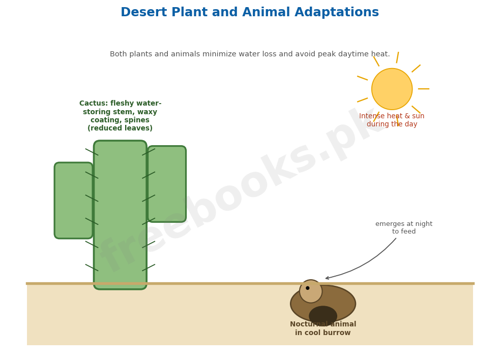
Deserts receive less than 25-50 cm (10-20 inches) of rainfall or none at all; plants are often evenly spaced, frequently as bushes or cacti with large shallow root systems, covered with waterproof waxy coatings to prevent water evaporation, and storing water in thick stems (as in cacti and Euphorbia, which have fleshy stems for water storage during drought). Animals are also specially adapted to survive on little water; most deserts appear almost devoid of animal life during the day, as animals seek relief from sun and heat in cool underground burrows, emerging in the dark as the desert cools, with horned lizards, snakes and other reptiles feeding alongside mammals such as kangaroo rats and birds such as the burrowing owl. Most smaller animals survive without ever drinking, obtaining water from food and cellular respiration, while large animals such as desert bighorn sheep and camels depend on permanent water holes during the driest times. Human activities are causing the spread of deserts, a process called desertification; a dramatic example is occurring in the Sahel, bordering the southern edge of the Sahara in Africa, where twenty-five years of below-average rainfall coupled with rapid human population growth have caused a steady southward spread of desert, exceeding the land's carrying capacity and resulting in nearly irreversible productivity loss and massive famines, such as occurred in Ethiopia in the mid-1980s.
The Tundra Ecosystem and Human Impact on Ecosystems
The last biome before reaching the polar ice caps is the arctic tundra, a vast treeless region bordering the Arctic Ocean, describing vegetation types in treeless high latitudes between taiga and polar ice caps, as well as high altitudes above the timberline, such as the Karakoram and Hindu Kush mountains in Pakistan. Arctic tundra stretches across northern North America, northern Europe, and Siberia. The ground is carpeted with small perennial flowers and dwarf willows no more than a few centimetres tall, often with large lichen called reindeer moss; standing pools provide superb mosquito habitat, and mosquitoes and other insects provide food for numerous migratory birds (ducks and geese) that travel long distances to nest and raise young during the brief summer. Tundra vegetation supports lemmings, which are eaten by wolves, snowy owls, arctic foxes, and even grizzly bears.
The tundra is perhaps the most fragile of all biomes because of its short growing season – a willow just 10 centimetres (4 inches) tall may have a trunk 7 centimetres (3 inches) in diameter and be 50 years old – meaning human activities in the tundra leave scars that persist for centuries; fortunately, civilization's impact remains largely localized around oil drilling sites, pipelines, mines and military bases. More broadly, the expanding human population has left relatively few ecosystems undisturbed; our impact on natural ecosystems is so diverse and wide-ranging that it far exceeds the scope of any single chapter, and ecosystems dominated by people tend to be simpler, with fewer species and fewer community interactions than an undisturbed ecosystem.
Important Definitions
Weather
Short-term fluctuations in temperature, humidity, cloud cover, wind and precipitation over periods of hours or days.
Climate
The overall patterns of weather that prevail from year to year, even century to century, in a particular region.
Littoral zone
The near-shore zone of a lake with shallow water, abundant light, anchorage and nutrients, hosting the most diverse plant and animal communities.
Eutrophication
The process by which excessive nutrient enrichment of a water body (often from human activity) leads to excessive algal growth, oxygen depletion, and death of aquatic life.
Taiga
Northern coniferous forest, found across Eurasia and North America just south of the tundra, dominated by evergreen conifers adapted to harsh, cold winters.
Prairie
Temperate grassland lacking woody plants, such as the Prairies of North America or the Pampas of Argentina.
Savanna
Tropical grassland containing woody trees, distinguished from temperate treeless prairies.
Desertification
The process by which human activities and/or climatic factors cause the spread of desert conditions into previously non-desert land.
Key Facts
| Item | Fact |
|---|---|
| Ocean/sea surface coverage | Salt-water oceans and seas cover about 71% of Earth's surface; fresh water ecosystems cover less than 1%. |
| Light penetration depth for photosynthesis | At depths of 600 feet (about 180 m) or more, little light remains to power photosynthesis in aquatic ecosystems. |
| Temperate deciduous forest rainfall & temperature | Average rainfall 750-1500 mm; temperature ranges from 4°C to 30°C. |
| Grassland annual rainfall | Temperate grassland: about 250-750 mm annually; tropical/subtropical grassland: up to about 1500 mm (60 inches). |
| Grassland primary production | Temperate grassland: 700-1500 g/m² annually; sub-humid tropical grassland: more than 4000 g/m² annually. |
| Desert rainfall | Deserts receive less than 25-50 cm (10-20 inches) of rainfall annually, or none at all. |
| 3 lake life zones | A lake ecosystem has three main life zones: littoral (near-shore), limnetic (open water, upper), and profundal (open water, deep). |
| Desert & grassland latitude band | Many of the world's major deserts and grasslands occur around 20° to 30° north and south latitude. |
Diagrams & Illustrations
Lake Ecosystem: The Three Life Zones: a cross-section diagram of a fresh water lake showing the three life zones: the littoral (near-shore) zone with rooted plants, the limnetic (open water, upper) zone with phytoplankton, and the profundal (deep, dark) zone with decomposers.
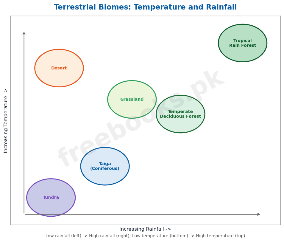
Terrestrial Biomes: Temperature and Rainfall: a diagram plotting the major terrestrial biomes (tundra, taiga/coniferous forest, temperate deciduous forest, grassland, desert) on axes of temperature and rainfall, showing how each biome's characteristic climate conditions determine its position.
Desert Plant and Animal Adaptations: a diagram showing desert survival adaptations: a cactus with a thick, water-storing fleshy stem and waxy coating and reduced leaves (spines), alongside a burrowing nocturnal animal emerging from an underground burrow at night to avoid daytime heat.
Short Questions & Answers
Define productivity of an ecosystem.
Productivity of an ecosystem is the rate at which producers convert light energy into organic matter through photosynthesis, indicated by the consumption of carbon dioxide and evolution of oxygen; in aquatic ecosystems it is determined mainly by light and nutrient availability.
List four adaptations in plants and animals for terrestrial life.
Terrestrial adaptations include supporting tissues (vascular bundles/xylem-phloem in plants, skeletons in animals) to withstand gravity, water conservation mechanisms such as homeostasis, temperature regulation structures such as bark in plants and skin in animals, and waterproof coverings to reduce water loss.
Name the three zones in a lake ecosystem.
The three zones in a lake ecosystem are the littoral zone (near-shore, shallow, most diverse), the limnetic zone (open water, upper, supports photosynthesis), and the profundal zone (open water, deep, insufficient light for photosynthesis, dominated by decomposers).
Name five major biomes found in the world.
Five major biomes include temperate deciduous forest, coniferous forest (taiga), grassland, desert, and tundra; tropical rain forest is another major biome.
Give the names of some major ecosystems on land in Pakistan.
Major terrestrial ecosystems in Pakistan include temperate deciduous forests (Shogran, Neelam valley), coniferous alpine and boreal forests (Kaghan, Swat, Dir, Chilas), grassland (Gilgit, Kashmir, Waziristan), desert (Thal in Punjab, Thar in Sindh, Cholistan), and tundra (Karakoram and Hindu Kush mountains).
What causes eutrophication of lakes, and what are its effects?
Eutrophication is caused by excess nutrients (phosphates and nitrates) entering lakes from sewage, farm feedlots and fertilizer runoff, leading to excessive algal growth that blocks sunlight to submerged plants; when algae and plants die and decompose, bacteria deplete dissolved oxygen, killing fish and other aquatic life.
Long Questions & Answers
Distinguish between the three different zones in a lake ecosystem, describing the light, organisms and productivity characteristic of each.
A fresh water lake, despite superficially appearing to be a single uniform body of water, is in fact ecologically organized into three clearly distinguishable life zones, each defined primarily by its differing degree of access to sunlight, dissolved nutrients, and suitable surfaces for anchorage, and properly understanding the overall ecology of a lake requires examining each of these three zones carefully in turn, moving progressively outward and downward from the shoreline toward the deepest open water. The first and shallowest of these three zones is the littoral zone, situated immediately near the shoreline, where the water remains comparatively shallow throughout and where rooted plants consequently find abundant available sunlight, secure anchorage directly in the bottom sediments, and an adequate ongoing supply of nutrients likewise drawn from those same bottom sediments; plant communities within the littoral zone are consistently found to be the most diverse of any zone within the lake, characteristically including floating water lilies together with fully submerged vascular plants and various forms of algae, and the plants rooted within this particular zone additionally perform the valuable ecological function of physically trapping sediment carried into the lake by inflowing streams, thereby further increasing the already substantial nutrient content of this region over time; living among these anchored littoral plants are numerous microscopic planktonic organisms, conventionally subdivided into phytoplankton (a term derived from the Greek for 'drifting plants,' encompassing various photosynthetic protists, bacteria and algae) and zooplankton (correspondingly 'drifting animals,' encompassing protozoa and various tiny crustaceans), and the littoral zone additionally supports the single greatest overall diversity of animal life found anywhere within the lake, including littoral invertebrates such as small crustaceans, various insect larvae, snails, flatworms and Hydra, together with vertebrates such as frogs, aquatic snakes and turtles. As the water progressively increases in depth moving farther away from the shoreline, rooted plants eventually become physically unable to simultaneously maintain anchorage to the lake bottom while still collecting sufficient sunlight to sustain active photosynthesis, and this deeper open-water portion of the lake is accordingly further subdivided into two additional, vertically stacked zones: the upper limnetic zone, in which sufficient sunlight still penetrates the water column to actively support ongoing photosynthesis, supporting phytoplankton, including cyanobacteria (commonly known as blue-green algae), functioning here as the zone's primary producers, which are in turn consumed by protozoa and small crustaceans, which are themselves subsequently consumed by fish; and the considerably deeper profundal zone lying directly beneath it, in which the available sunlight has by this depth become far too weak or insufficient to support any meaningful photosynthesis whatsoever, meaning that organisms inhabiting this deepest zone must instead obtain their nourishment primarily from detritus (organic debris) continuously falling downward from the littoral and limnetic zones above, together with incoming sediment, so that the profundal zone is consequently characteristically inhabited mainly by decomposers and various detritus-feeding organisms, including snails, certain specialized insect larvae, bacteria, fungi and bottom-dwelling fish species. Taken together, these three vertically and horizontally distinct zones, the shallow, sunlit, biologically diverse littoral zone; the intermediate, still photosynthetically active limnetic zone; and the deep, dark, detritus-dependent profundal zone, collectively illustrate how a single lake ecosystem's overall productivity and species diversity are fundamentally organized and structured according to the underlying availability of light, nutrients, and secure surfaces for anchorage at each successive depth.
Compare the climate, plant adaptations, and animal life of the grassland and desert ecosystems, and describe the human impact on each.
Grassland ecosystems and desert ecosystems, although both are broadly classified as terrestrial biomes and although both are frequently found occurring within roughly similar latitudinal bands around the globe, nevertheless differ from one another quite substantially and instructively in terms of their characteristic climate, in the specific survival adaptations exhibited by their resident plant and animal life, and in the particular nature of the various human impacts to which each biome type has historically been subjected, and examining each of these three dimensions of comparison in turn helps to make the underlying ecological contrast between these two important biome types considerably clearer. In terms of underlying climate, grassland ecosystems, found in Pakistan specifically in regions such as Gilgit, Kashmir, Waziristan, lower Chitral and North Kalat, characteristically experience an annual rainfall total of roughly 250 to 750 millimetres in temperate grassland regions, rising to as much as approximately 1500 millimetres in tropical and sub-tropical grassland regions, occurring specifically in those geographic regions where the overall mean annual rainfall total happens to fall roughly midway between the generally much higher rainfall totals characteristic of forest ecosystems and the generally much lower rainfall totals characteristic of true desert ecosystems; desert ecosystems, by clear contrast, found in Pakistan specifically in regions such as the Thal desert of western Punjab and the Thar desert of Sindh, characteristically receive substantially less rainfall overall, typically amounting to less than roughly 25 to 50 centimetres annually, and in certain particularly extreme desert regions such as parts of the Sahara or the Atacama desert in Chile, virtually no meaningful rainfall occurs at all. In terms of characteristic plant adaptations, grassland vegetation is overwhelmingly dominated by graminoids, meaning true grasses together with various grass-like plants, frequently supplemented by scattered herbaceous forbs such as various composite and legume species, with grassland vegetation additionally displaying a distinctive layered vertical structure, comprising an uppermost layer of taller grass species, a middle layer of intermediate-height grass species, and a lowest layer made up of shorter grasses together with forbs, mosses and lichens; desert plant life, by contrast, has instead evolved a substantially different and more specialized suite of adaptations specifically oriented toward minimizing water loss and maximizing water storage under conditions of severe and prolonged water scarcity, including a distinctive waterproof waxy surface coating that helps to significantly reduce evaporative water loss, together with specialized fleshy, thickened stems, as seen in cacti and various Euphorbia species, specifically adapted to store substantial reserves of water internally for later use during extended drought periods, along with typically widely spaced individual plant distribution patterns and comparatively large but very shallow root systems specifically adapted to rapidly capture whatever limited rainfall does occasionally occur. In terms of characteristic animal life, grassland ecosystems typically support comparatively large overall populations of herbivorous animals, together with numerous associated invertebrate species, including grasshoppers, which can at times become numerous enough to directly compete with larger herbivores for available plant foliage, together with various predatory reptiles, amphibians and mammals such as lizards, toads, foxes and wolves, and with larger characteristic grassland animals including zebras, wild horses and bison; desert animal life, by contrast, has instead evolved a substantially different and more specialized set of behavioural and physiological adaptations specifically oriented toward avoiding the most extreme daytime heat and conserving the limited available water, with the great majority of desert animal species accordingly remaining concealed within cool underground burrows throughout the heat of the day and instead emerging to actively feed only after nightfall, once temperatures have meaningfully cooled, including horned lizards, snakes and various other reptile species together with mammals such as kangaroo rats and birds such as the burrowing owl, with many smaller desert animal species additionally managing to survive entirely without ever directly drinking any water at all, instead obtaining all of the water they require metabolically from their food and from the water produced internally as a natural by-product of ordinary cellular respiration. Finally, in terms of characteristic human impact, grassland ecosystems have historically been very extensively impacted by widespread crop cultivation and livestock grazing activity, with excessive overgrazing in particular characteristically leading directly to significant reduction of the natural herbage cover, substantially increased soil erosion, and, in especially severe cases, eventual outright desertification of previously productive grassland; desert ecosystems, by contrast, face the somewhat different but closely related human-driven threat of desertification actively spreading outward from existing desert regions into adjacent, previously non-desert land, a process dramatically illustrated by the historical experience of the Sahel region bordering the southern edge of the Sahara desert in Africa, where a sustained twenty-five-year period of below-average rainfall, combined with rapid ongoing human population growth substantially exceeding the land's underlying ecological carrying capacity, together produced a steady, ongoing southward spread of desert conditions, ultimately resulting in a largely irreversible loss of ecosystem productivity and, tragically, in severe associated famines, such as the catastrophic famine that occurred in Ethiopia during the mid-1980s.
MCQs with Answers
Salt-water oceans and seas cover approximately what percentage of Earth's surface? (a) 25% (b) 50% (c) 71% (d) 90%
Correct Answer: (c) 71%. Salt-water oceans and seas are the largest ecosystems on earth, covering about 71% of its surface; fresh water ecosystems cover less than 1%.
Which lake zone has the greatest diversity of plants and animals? (a) Limnetic zone (b) Profundal zone (c) Littoral zone (d) Benthic zone
Correct Answer: (c) Littoral zone. The littoral (near-shore) zone has abundant light, anchorage and nutrients, making it the most diverse zone of a lake in both plant and animal life.
The process by which excess nutrients cause algal overgrowth and oxygen depletion in a lake is called: (a) denitrification (b) eutrophication (c) desertification (d) nitrification
Correct Answer: (b) eutrophication. Eutrophication is the process by which nutrient enrichment (often from sewage or fertilizer runoff) leads to excessive algal growth, followed by decomposition that depletes dissolved oxygen.
Northern coniferous forest, found across Eurasia and North America just south of the tundra, is also called: (a) savanna (b) prairie (c) taiga (d) chaparral
Correct Answer: (c) taiga. Northern coniferous forests are also called taiga; those at high altitude are called alpine, and those at high latitude are called boreal.
Temperate grasslands lacking woody plants, such as those of North America, are called: (a) savannas (b) prairies (c) taigas (d) tundras
Correct Answer: (b) prairies. Temperate grasslands without woody plants are called prairies (e.g. the Prairies of North America, the Pampas of Argentina); tropical grasslands with woody trees are called savannas.
In Sindh, Pakistan, the desert ecosystem is known as: (a) Thal (b) Thar (c) Cholistan (d) Sahel
Correct Answer: (b) Thar. In Sindh, the desert ecosystem is called 'Thar', while in western Punjab (Mianwali, Bhakkar) it is called 'Thal'.
The Sahel region, where desertification has caused severe famine, borders which desert? (a) Thar Desert (b) Atacama Desert (c) Sahara Desert (d) Gobi Desert
Correct Answer: (c) Sahara Desert. The Sahel borders the southern edge of the Sahara Desert in Africa, where below-average rainfall and population growth caused desertification and famine, notably in Ethiopia in the mid-1980s.
Which of the following is a key adaptation of desert plants such as cacti? (a) Broad thin leaves for maximum photosynthesis (b) Thick, water-storing fleshy stems (c) Deep taproots reaching the water table (d) Deciduous leaf-shedding in winter
Correct Answer: (b) Thick, water-storing fleshy stems. Desert plants such as cacti and Euphorbia have thick, fleshy stems that store water for use during drought, along with waterproof waxy coatings to reduce evaporation.
The tundra biome is bordered by which two regions? (a) Desert and grassland (b) Taiga and polar ice caps (c) Temperate forest and taiga (d) Savanna and desert
Correct Answer: (b) Taiga and polar ice caps. Tundra describes treeless vegetation in high latitudes between taiga (coniferous forest) and the polar ice caps, and at high altitudes above the timberline.
Which mountain ranges in Pakistan host the tundra ecosystem? (a) Sulaiman and Kirthar (b) Margalla Hills (c) Karakoram and Hindu Kush (d) Salt Range
Correct Answer: (c) Karakoram and Hindu Kush. In Pakistan, the tundra ecosystem occurs at high altitude in the Karakoram and Hindu Kush mountain ranges.
Quick Revision Summary
- Weather (short-term) vs Climate (long-term patterns). Hydrospheric ecosystem: oceans/seas = 71% of Earth surface, fresh water <1%. Aquatic features: moderate temperature, light decreases with depth (little light below 600 ft), nutrients concentrate at bottom.
- Lake ecosystem = 3 zones: Littoral (near-shore, most diverse, rooted plants + plankton) -> Limnetic (open water, upper, photosynthesis) -> Profundal (deep, dark, decomposers/detritus feeders). Eutrophication: excess nutrients (sewage/fertilizer) -> algal bloom -> death -> bacterial decomposition -> oxygen depletion -> fish kill.
- Terrestrial ecosystem: plenty light + nutrients, but limited/uneven water. Adaptations: supporting tissues (xylem-phloem/skeleton), water conservation (homeostasis), temperature regulation (bark/skin). Division: Forest (tropical rain/temperate deciduous/coniferous) + Grassland + Desert + Tundra.
- Pakistan ecosystems: Temperate deciduous forest (Shogran, Neelam valley) | Coniferous/taiga (Kaghan, Swat, Dir, Chilas) | Grassland (Gilgit, Kashmir, Waziristan) | Desert (Thal-Punjab, Thar-Sindh, Cholistan) | Tundra (Karakoram, Hindu Kush).
- Temperate deciduous forest: rainfall 750-1500mm, temp 4-30C, deciduous (sheds leaves in dry season), fertile grayish-brown soil. Taiga/coniferous: harsh cold winters, evergreen waxy-needle conifers, low biodiversity, major lumber source.
- Grassland: rainfall 250-750mm (up to 1500mm tropical), prairie (temperate, no trees) vs savanna (tropical, has trees), 3-layer structure (tall/mid/short grasses), overgrazing -> desertification. Desert: <25-50cm rainfall, waxy/fleshy water-storing plants, nocturnal animals, desertification (e.g. Sahel/Sahara).
- Tundra: treeless, between taiga & polar ice caps (also high altitude e.g. Karakoram/Hindu Kush), dwarf plants + reindeer moss, lemmings/wolves/arctic foxes, most fragile biome (slow growth, scars persist centuries). Human impact overall: simplifies ecosystems (fewer species/interactions). Notes by freebooks.pk.
Exam Tips
- Keep weather (hours/days, short-term) vs climate (years/centuries, long-term pattern) as a clean opposite pair – a frequently tested basic distinction.
- Memorise the 3 lake zones in order from shore to deep water (littoral -> limnetic -> profundal) along with one defining feature each (most diverse / photosynthesis / decomposers) rather than just definitions.
- Build a Pakistan-ecosystem location table (5 rows: forest/coniferous/grassland/desert/tundra with their specific regions) – this exact mapping is commonly tested in short and extensive questions.
- Keep prairie (temperate, no trees) vs savanna (tropical, has trees) as a clear opposite pair when discussing grasslands.
- Memorise the key numeric ranges for each biome (temperate forest: 750-1500mm rainfall, 4-30C; grassland: 250-750mm; desert: <25-50cm) as they are commonly tested as fill-in-the-blank or short-answer facts.
- Build a simple 2-column adaptation table for desert plants vs desert animals (waxy coating/fleshy stems vs nocturnal behaviour/burrows) to directly answer common extensive questions.
- Remember 3 concrete named examples of desertification/human impact (Sahel/Sahara famine, overgrazing in grasslands, tundra oil/pipeline scars) as ready-made exam examples.